South Castor River
Protecting People and Property
South Nation Conservation (SNC) invites watershed residents living along South Castor River within the City of Ottawa and the United Counties of Stormont Dundas and Glengarry (SDG), to view draft floodplain mapping (or natural hazard maps).
These natural hazard maps have been developed on behalf of the City of Ottawa and SDG and will be used when updating Official Plans and zoning schedules, and when reviewing development applications to protect people and property from natural hazards and guide sustainable development activities.
Regulation areas included on draft maps include the greatest of whichever natural hazard is present: floodplain or riverine erosion. It's important to speak with the Conservation Authority when considering developing in these areas to determine what type of hazard or constraint may exist.
Development projects within natural hazard areas (like floodplains) require permission from the Conservation Authority before proceeding. Please visit SNC's Regulations Webpage to learn more about regulations made under the Conservation Authorities Act O.Reg 41/24 Prohibited Activities, Exemptions and Permits
Public Consultations
When updating natural hazard maps after completing a comprehensive study, Conservation Authorities will invite affected property owners to review draft maps and provide any comments during public consultations.
Consultations help update Regulation Areas where permission (through a permit) may be required for certain construction or shoreline development activities. Please note that these consultations do not replace any municipal requirements or public notices to update policies or zoning schedules
Residents and stakeholders with properties along South Castor River within the City of Ottawa and Counties of SDG are welcome to book a 1-on-1 meeting with SNC staff to learn more about the floodplain mapping project.
Join us!
Residents are invited to drop by the Open House or schedule a meeting at the SNC Office to meet with staff on the following dates:
Open House
Tuesday, November 17, 2026
6:00 pm to 8:00 pm
Vernon Recreation Centre - Hall. (7950 Lawrence Street, Vernon, ONThis link opens in a new window)
(Drop-in any time between 6pm and 8pm)
1-on-1 Meeting with SNC Staff
Thursday, November 19, 2026
9:00am to 4:00pm
SNC Administrative Office (38 Victoria Street, Finch, ON)This link opens in a new window
(Schedule your meeting here: 1-on-1 Meeting Request FormThis link opens in a new window)
Can't make it to the Open House on November 17?
Residents who wish to learn more can schedule a phone, virtual or in-person meeting with SNC on weekdays between November 18 and December 4.
 Schedule your meeting with SNC by completing the online Meeting Request Form here:
PUBLIC CONSULTATIONS: Natural Hazards Mapping: 1-on-1 Meeting Request – Fill out form
Maps
Final natural hazard mapping reports are added to SNC's website and the updated maps are added to SNC's public Geoportal.
Note: The maps of South Castor River are not yet approved by SNC's Board of Directors and remain in draft form until after the public consultation period.
Please note that the "Regulation Area" is displayed on draft mapping. This area includes the greatest of either hazard: 1:100 year floodplain or riverine erosion hazard, plus a buffer. Examples will be shared during consultation meetings.
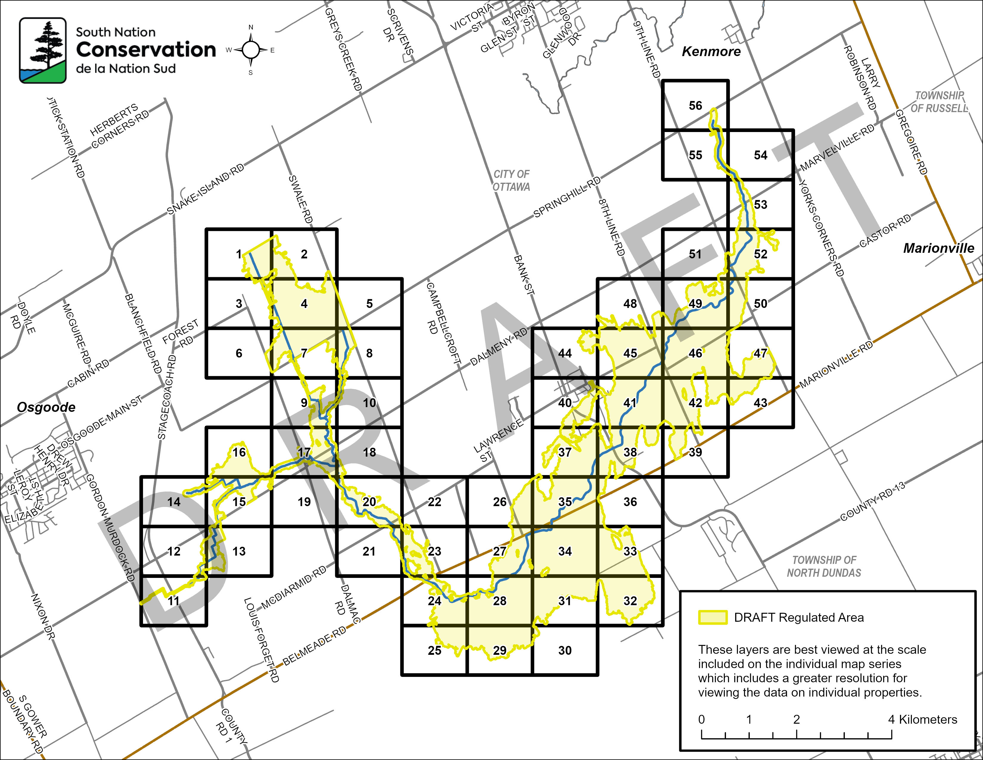
Download a PDF version here: South Castor River Draft Reg Keymap
To view an individual floodplain map, find the numbered section on the Key Map of the mapped area above and click the corresponding numbered link below:
MAP 1
MAP 11
MAP 21
MAP 31
MAP 41
MAP 51
MAP 2
MAP 12
MAP 22
MAP 32
MAP 42
MAP 52
MAP 3
MAP 13
MAP 23
MAP 33
MAP 43
MAP 53
MAP 4
MAP 14
MAP 24
MAP 34
MAP 44
MAP 54
MAP 5
MAP 15
MAP 25
MAP 35
MAP 45
MAP 55
MAP 6
MAP 16
MAP 26
MAP 36
MAP 46
MAP 56
MAP 7
MAP 17
MAP 27
MAP 37
MAP 47
MAP 8
MAP 18
MAP 28
MAP 38
MAP 48
MAP 9
MAP 19
MAP 29
MAP 39
MAP 49
MAP 10
MAP 20
MAP 30
MAP 40
MAP 50
Additional Resources
Understanding flood messages and preparing your family and property for a potential flood is the best defence.
SNC has prepared resources to provide guidance to property owners before and after a flood event. Flooding can create problems in and around your home; take a moment to become familiar with these resources. Stay up to date with your municipality during emergency response.
- What is a Floodplain?
- Permitting in Protected Areas
- Preparing for Flood Events
- After the Flood; Your Septic System
- After the Flood; Your Well
- Cleaning Up After the Flood